
Interactive GIS Mapping for Airports
Modern, FAA-compliant airport mapping built for operational insight, safety, and efficiency.
Power Your Airport with Interactive FAA-Compliant Mapping
AirSafe Measurements delivers custom-built, web-based GIS maps designed specifically for airport operations, planning, and compliance.
We combine FAA design standards, high-resolution imagery, and interactive map tools to provide a complete spatial understanding of your airfield—accessible anywhere, anytime.

Designed for Airport Professionals
Airport Managers & Operations Specialists – simplify compliance reviews and inspections.
Planning & Engineering Teams – evaluate proposed development quickly and accurately.
Consultants & Contractors – communicate with stakeholders using clear, visual data.
Key Features
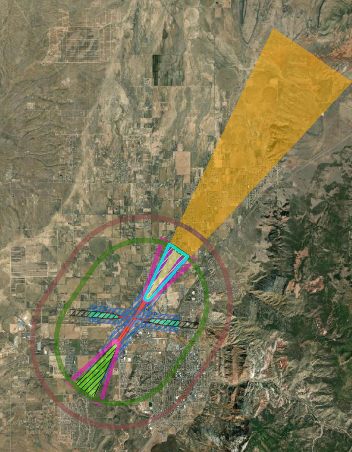
Part 77 Imaginary Surfaces - Visualize approach, transitional, horizontal, and conical surfaces for easy obstacle management and planning.
Runway & Taxiway Safety Areas - Clearly defined RSA, OFA, and TOFA zones ensure compliance with FAA design standards.
Obstacle Data Integration - FAA obstacle databases and custom field-collected data integrated directly into your map for accurate analysis.
Sign & Lighting Layers - Digitally manage airfield lighting, marking, and sign inventories using dynamic GIS layers.
Up-to-Date Imagery - High-resolution satellite imagery keeps your base map current for inspections and planning.
Mobile Integration - Directly accessible through the AirSafe 139 app—link work orders, or inspections to map features( Pending your inspection software).
Why Airports Choose AirSafe Measurements
Tailored for Part 139 Operations
Built by professionals with airfield experience—our maps speak the same language as your inspectors and managers.
Cost-Effective Alternative to In-House GIS
Avoid the overhead of hiring specialists or maintaining complex GIS infrastructure—we handle the data, hosting, and updates for you.
Faster Decision-Making & Visualization
Instantly identify penetrations, closures, or maintenance zones with color-coded layers and filters.
Secure, Hosted, and Always Up-to-Date
Your map is cloud-hosted, accessible only to authorized users, and updated annually or as your data changes.

Flexible Pricing for Airports of All Sizes
Tier 1
Ideal for: Very Small/Small Airports
Includes: Runway & Taxiway Safety Areas, Sign & Lighting Layers, Updated Imagery, Base Interactive Map
Pricing*: Starting at $10,000 + Annual Hosting / Maintenance Fee ($3,500).
Tier 2
Ideal for: Small/Medium Airports
Includes: Tier 1 + Part 77 Imaginary Surfaces, FAA Obstacle Integration
Pricing*: Starting at $14,500 + Annual Hosting / Maintenance Fee ($5,000).
Tier 3
Ideal for: Medium/Large Airports
Includes: Tier 2 + Full suite + custom add-ons (drone imagery, advanced NOTAM or inspection integration)
Pricing*: Custom Quote
*Prices are estimates and subject to change based on airport complexity and scope. Annual hosting includes updates, maintenance, and support; custom features may incur additional cost.


Updated Orthomosaic & Drone Data Integration (Coming Soon)
AirSafe Measurements will soon offer regular drone imagery updates for airports, creating up-to-date orthomosaics tied directly into your interactive Part 77 maps.


Ready to Elevate Your Airport’s Safety & Compliance?
Contact us today to learn more about our interactive Part 77 mapping services.
Disclaimer: These maps are for informational and planning purposes only and are not FAA-certified engineering documents.